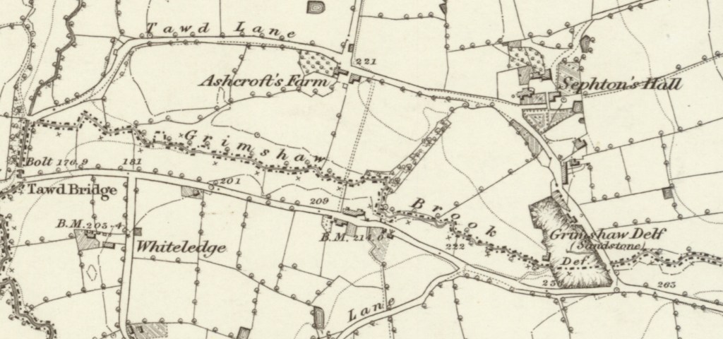
Grimshaw was an area of rural Skelmersdale that contained a quarry (or “delf”). There was also a house or farm to the north east of the delf. This was near the Grimshaw Brook and Tawd Lane. In the same area were Sephtons Hall, Ashcrofts Farm and Whiteledge.
This is the 1848 map of the area. The house to the north east of the delf is not labelled but is called Grimshaw Delf Farm in later maps. There are also a couple of buildings on the delf itself.
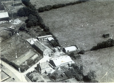
See Red Rose Collections for more information, including this image which is of “Grimshaw Delph Farm” on Tawd Road, shortly before the newtown was built, with Sephton’s Hall Farm Buildings on upper left, which would correspond to the buildings on the 1848 map.
Ancestor John Barton, his daughter Ellen and her son Thomas Barton lived at Grimshaw in the 1841 census, where John was the Delfmaster. From the census it is unclear whether John lived in the farm or in the buildings attached to the delf.
The original census entries for 1841 give an idea of the people living in the area
- Sheet 1
- School Estate (there is a School Farm to west of Houghton’s)
- James Ormesher, farmer
- Houghton’s (this is north of Sephton’s Hall)
- John Morris?, farmer
- Near Sephton’s Hall
- Thomas Wilkinson, farmer
- Sephton’s Hall
- Evan Mawdsley, farmer
- Ashton’s (early name for Grimshaw Delf Farm, see below)
- James Worsley, farmer
- Kiln’s? (6 households) (cottages to immediate north of delf, see below)
- John Wilson, weaver
- Richard Wilson, weaver
- Thomas Matthew, weaver
- James Pennington, weaver
- Edward Heaton, weaver
- Martha Howarth, weaver
- School Estate (there is a School Farm to west of Houghton’s)
- Sheet 2
- Grimshaw (delf buildings?)
- John Barton, delf master
- Tawd House (this is a distance to west of Grimshaw, past Tawd Bridge)
- James Renfoot?, farmer
- Martin’s (3 households)
- Gerorge Taylor, grocer?
- Ellen Rosebottom?, ???
- Thomas Myers?, agricultural labourer
- Grimshaw (delf buildings?)
- Sheet 3
- Chapel Land?
- John Renforth?, farmer
- Ri??? House
- William Pennington
- Forshaw’s
- Hugh Forshaw?, blacksmith
- Blundells’s
- William Langton?, farmer
- Chapel Land?
Below is the Tithe Map of the Grimshaw area from 1838, from which we can see that John Barton occupied the delf plus a cottage and garden on the eastern border of the delf. The buildings later known as Grimshaw Delf Farm, between the delf and Sephton’s Hall, were occupied by James Worsley who is listed as living at “Ashton’s” in the 1841 census and the tithe details show that Thomas Ashton owned the properties. So that proves that, at least in 1838, John Barton was living by Grimshaw delf, not at the farm between Sephton’s Hall and the delf. John Barton also occupied another delf to the north of Sephton’s Hall.
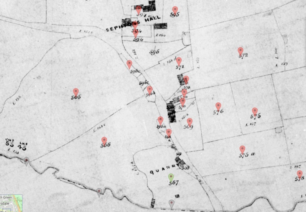
The tithe map plot numbers are as follows
- 565: “Steal Field” occupied by Thomas Wilkinson (living “near Sephtons Hall” in the 1841 census), owned by Lord Skelmersdale
- 566: “Delf Meadow” occupied by James Worsley (living at “Ashton’s” in the 1841 census), owned by Thomas Ashton
- 567: “Delf and Smithy” occupied by John Barton, owned by Thomas Ashton, the smithy is presumably the building to south west of the delf?
- 1238: “Grimshaw Delf” occupied by Henry Gaskell, owned by Thomas Walker, not sure how this differs from “Delf” occupied by John Barton, perhaps this was the field next to the delf
- 568: “Cottage and Garden” occupied by John Barton, owned by Lord Skelmersdale
- 596: “Croft” occupied by Evan Mawdsley (living at Sephton’s Hall in 1841 census), owned by James Culshaw, this is to immediate north of “Delf and Smithy”
- 596a: “Two Cottages and Garden” occupied by Richard Wilson & Thomas Pennington (both weavers living at “Kiln’s” in the 1841 census), owned by Thomas Rosebottom
- 509: “Near Moss” occupied by James Meadows, owned by Lord Skelmersdale
- 570: “Farm House Outbuildings & Garden” occupied by James Worsley (living at “Ashton’s” in the 1841 census), owned by Thomas Ashton
- 596b: “Two Cottages and Garden” occupied by Edward Eaton & James Bennington (both weavers living at “Kiln’s” in the 1841 census), owned by Thomas Barton
- 596c: “2 Cottages & Gardens” occupied by Martha Howarth (weaver living at “Kiln’s” in the 1841 census)
- 571: “Old Orchard” occupied by James Worsley (living at “Ashton’s” in the 1841 census), owned by Thomas Ashton
- 596: “Croft” occupied by Evan Mawdsley, owned by James Culshaw
- 594: “Septons Hall Outbuildings Folds” occupied by Evan Mawdsley, owned by James Culshaw
- 595: “Stock Croft” occupied by Evan Mawdsley, owned by James Culshaw
- 591: “Rough Hey” occupied by Evan Mawdsley, owned by James Culshaw
- 633: (off map to the north of Sephtons Hall) “Delf” occupied by John Barton, owned by James Culshaw
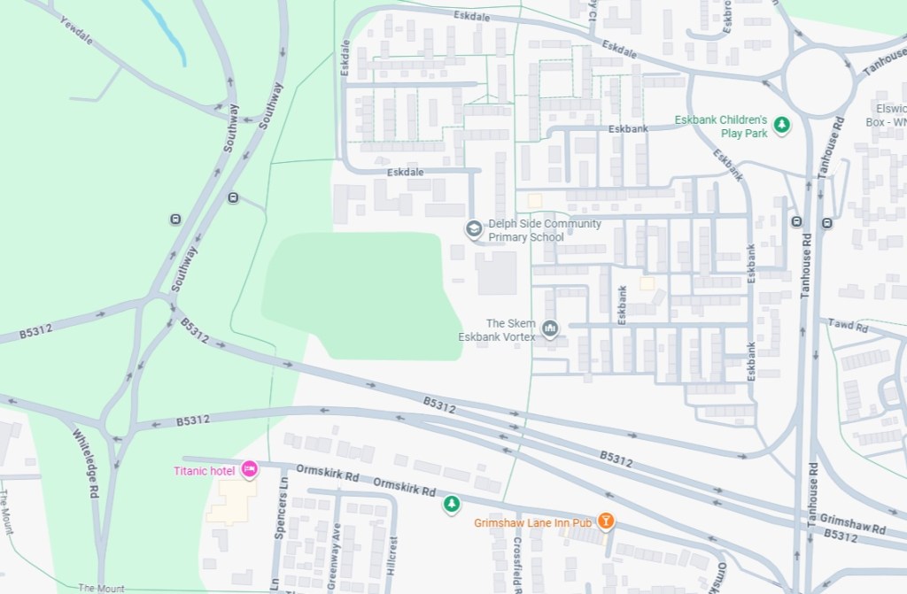
The whole area was built over by the new town of Skelmersdale.
On the modern map the Grimshaw Delf and farm are likely to be to the north of Grimshaw Road and west of Tawd Road (there are other references to original features such as Delph Side and Whiteledge Road).